
search
Lisbon ferry map
Map of lisbon ferry. Lisbon ferry map (Portugal) to print. Lisbon ferry map (Portugal) to download. As Lisbon stretches along the banks of the Tagus estuary, ferries are an integral part of the capital public transport network. Ferry lines as its shown in the lisbon ferry map offer another way to get to the residential areas in the south of Lisbon, avoiding the traffic jams at the suspension bridge of April 25. For visitors to Lisbon, ferries are both a pleasant and cheap activity, as they offer great views of the city for a fraction of the price of what tourist boats charge. This article offers a tourist guide to Lisbon ferries, presents the main routes, fares and links to timetables.
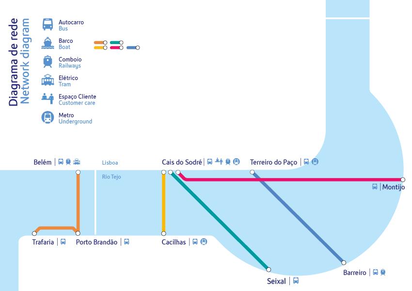
There are five ferry lines mentioned in the lisbon ferry map accessible from the three Lisbon ferry stations and from the four ferry stations on the southern shores. The ferry lines are as follows: From Terreiro do Paço to Barreiro, From Cais do Sodré to Montijo, From Cais do Sodré to Seixal, From Cais do Sodré to Cacilhas (recommended), From Belém to Porto Brandão and Trafaria (recommended). The two most important terminals are Terreiro do Paço and Cais do Sodré, as they are close to downtown Lisbon. The Belém terminal is a little less important and is located to the west of the city. The busiest line is the one between Cais do Sodré and Cacilhas.